
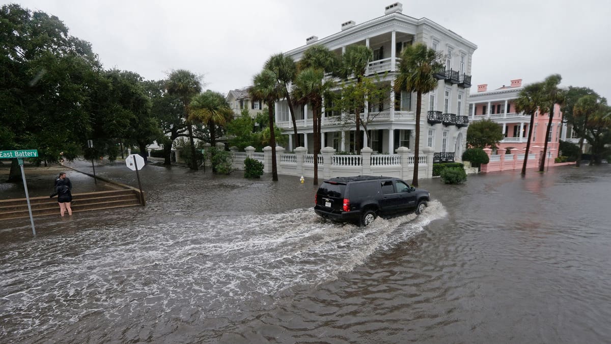

Hurricane Idalia
One of the more serious weather related events. However there is usually time to prepare. Click here for the Stier Supply Company hurricane preparedness webpage.

Hot and Cold
The cold of what little winter we have is not too difficult to deal with, but the HEAT can be exhausting and even deadly.

Thunderstorms
A common occurrence in the Southeast but they deserve a common sense approach to avoid the hazards associated with their sometimes daily assault.

Stier Supply Co.
1-803-256-1646
303 Bellinger ln
Gaston, SC 29053
- What is hail?
- Hail is a form of precipitation consisting of solid ice that forms inside thunderstorm updrafts. Hail can damage aircraft, homes and cars, and can be deadly to livestock and people.
- How does hail form?
- Hailstones are formed when raindrops are carried upward by thunderstorm updrafts into extremely cold areas of the atmosphere and freeze. Hailstones then grow by colliding with liquid water drops that freeze onto the hailstone’s surface. If the water freezes instantaneously when colliding with the hailstone, cloudy ice will form as air bubbles will be trapped in the newly formed ice. However, if the water freezes slowly, the air bubbles can escape and the new ice will be clear. The hail falls when the thunderstorm's updraft can no longer support the weight of the hailstone, which can occur if the stone becomes large enough or the updraft weakens.
Hailstones can have layers of clear and cloudy ice if the hailstone encounters different temperature and liquid water content conditions in the thunderstorm. The conditions experienced by the hailstone can change as it passes horizontally across or near an updraft. The layers, however, do not occur simply due to the hailstone going through up and down cycles inside a thunderstorm. The winds inside a thunderstorm aren’t simply up and down; horizontal winds exist from either a rotating updraft, like in supercell thunderstorms, or from the surrounding environment’s horizontal winds. Hailstones also do not grow from being lofted to the top of the thunderstorm. At very high altitudes, the air is cold enough (below -40°F) that all liquid water will have frozen into ice, and hailstones need liquid water to grow to an appreciable size.
- How does hail fall to the ground?
- Hail falls when it becomes heavy enough to overcome the strength of the thunderstorm updraft and is pulled toward the earth by gravity. Smaller hailstones can be blown away from the updraft by horizontal winds, so larger hail typically falls closer to the updraft than smaller hail. If the winds near the surface are strong enough, hail can fall at an angle or even nearly sideways! Wind-driven hail can tear up siding on houses, break windows and blow into houses, break side windows on cars, and cause severe injury and/or death to people and animals.
- How fast does hail fall?
- This is a very complicated answer. The fall speed of hail primarily depends on the size of the hailstone, the friction between the hailstone and surrounding air, the local wind conditions (both horizontal and vertical), and the degree of melting of the hailstone. Early research assumed that hailstones fell like solid ice spheres and showed very high fall speeds, even for very small hailstones. However, recent research outside of NSSL using 3-D printed casts of real hailstones suspended in a vertical wind tunnel has repeatedly shown that natural hailstones fall more slowly than solid ice spheres. For small hailstones (<1-inch in diameter), the expected fall speed is between 9 and 25 mph. For hailstones that one would typically see in a severe thunderstorm (1-inch to 1.75-inch in diameter), the expected fall speed is between 25 and 40 mph. In the strongest supercells that produce some of the largest hail one might expect to see (2-inches to 4-inches in diameter), the expected fall speed is between 44 and 72 mph. However, there is much uncertainty in these estimates due to variability in the hailstone’s shape, degree of melting, fall orientation, and the environmental conditions. However, it is possible for very large hailstones (diameters exceeding 4-inches) to fall at over 100 mph.
- What areas have the most hail?
- Although Florida has the most thunderstorms, Nebraska, Colorado, and Wyoming usually have the most hailstorms. The area where these three states meet – “hail alley” – averages seven to nine hail days per year. Other parts of the world that have damaging hailstorms include China, Russia, India and northern Italy.
When viewed from the air, it is evident that hail falls in paths known as hail swaths. These occur as storms move while the hail is falling out They can range in size from a few acres to an area 10 miles wide and 100 miles long. Some storms, instead of producing large hail, instead produce copious amounts of small hail. Storms like these have produced hail drifts that, when captured in clogged drainage channels, formed piles of hail several feet deep. Hail that completely covers roadways is especially hazardous because if deep enough, a vehicle’s tires may not touch the roadway at all, with the vehicle instead driving on the hail, which acts exactly like an icy roadway in the winter.
- How large can hail get?
- The largest hailstone recovered in the United States fell in Vivian, South Dakota, on June 23, 2010, with a diameter of 8 inches and a circumference of 18.62 inches. It weighed 1 lb 15 oz.
- Estimating Hail Size
- Hail size is often estimated by comparing it to a known object. Most hailstorms are made up of a mix of different sizes, and only the very largest hail stones pose serious risk to people caught in the open. When reporting hail, estimates comparing the hail to a known object with definite size are good, but measurements using a ruler, calipers, or a tape measure are best.
- Pea = 1/4 inch diameter
- Mothball = 1/2 inch diameter
- Penny = 3/4 inch diameter
- Nickel = 7/8 inch
- Quarter = 1 inch — hail quarter size or larger is considered severe
- Ping-Pong Ball = 1 1/2 inch
- Golf Ball = 1 3/4 inches
- Tennis Ball = 2 1/2 inches
- Baseball = 2 3/4 inches
- Tea cup = 3 inches
- Softball = 4 inches
- Grapefruit = 4 1/2 inches
Tornatoes Continued
■ The safest place to be is an underground shelter, basement, or safe room.
■ If no underground shelter or safe room is available, a small, windowless interior room or hallway on the lowest level of a sturdy building is the safest alternative.
■ Mobile homes are not safe during tornadoes. Abandon mobile homes and go to the nearest sturdy building or shelter immediately.
■ If you are caught outdoors, seek shelter in a basement, shelter or sturdy building. If you cannot quickly walk to a shelter:
■ Immediately get into a vehicle, buckle your seat belt and try to drive to the closest sturdy shelter.
■ If flying debris occurs while you are driving, pull over and park. Now you have the following options as a last resort:
■ Stay in your vehicle with the seat belt on. Put your head down below the windows, covering with your hands and a blanket if possible.
■ If you can safely get noticeably lower than the level of the roadway, exit your car, and lie in that area, covering your head with your hands.
■ Your choice should be driven by your specific circumstances
Occasionally tornadoes develop so rapidly that advance warning is not possible. Remain alert for signs of an approaching tornado such as a dark, often greenish sky, large hail, or a loud roar similar to a freight train.
When Dangerous Weather Approaches
Avoid the Lightning Threat
■ Have a lightning safety plan. Know where you'll go for safety and how much time it will take to get there. Make sure your plan allows enough time to reach safety.
■ Postpone activities. Before going outdoors, check the forecast for thunderstorms. Consider postponing activities to avoid being caught in a dangerous situation.
■ Monitor the weather. Look for signs of a developing thunderstorm such as darkening skies, flashes of lightning, or increasing wind.
■ Get to a safe place. If you hear thunder, even a distant rumble, immediately move to a safe place. When Thunder Roars, Go Indoors! Fully enclosed buildings with wiring and plumbing provide the best protection. Sheds, picnic shelters, tents or covered porches do not protect you from lightning. If a sturdy building is not nearby, get into a hard-topped metal vehicle and close all the windows. Stay inside until 30 minutes after the last rumble of thunder.
■ If you hear thunder, don't use a corded phone. Cordless phones, cell phones and other wireless handheld devices are safe to use.
■ Keep away from electrical equipment, wiring and water pipes . . Sensitive electronics should be unplugged well in advance of thunderstorms. Don't take a bath, shower or use other plumbing during a thunderstorm.
When Caught Outside During Thunder
There is no safe place outside during a thunderstorm. Plan ahead to avoid this dangerous situation! If you're outside and hear thunder, the only way to significantly reduce your risk of becoming a lightning casualty is to get inside a substantial building or hard-topped metal vehicle as fast as you can. Remember, there is no substitute for getting to a safe place.
■ Avoid open areas and stay away from isolated tall trees, towers, or utility poles. Do not be the tallest object in the area. Lightning tends to strike the tallest objects in the area.
■ Stay away from metal conductors such as wires or fence. Metal does not attract lightning, but lightning can travel long distances through it.
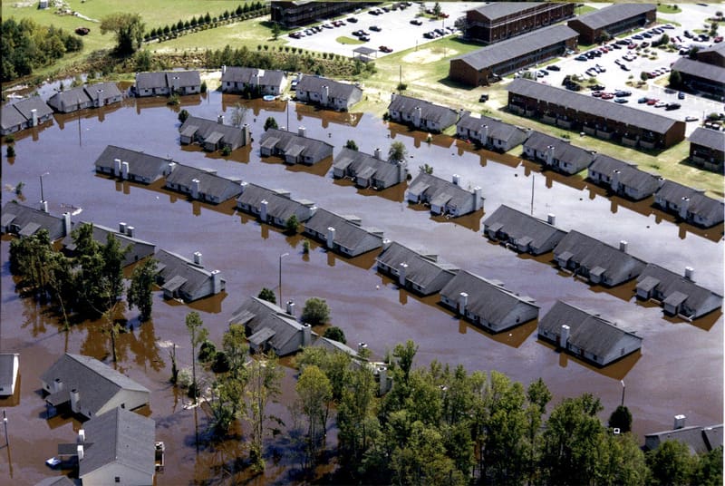
Flash Flood Safety Rules
■ Avoid driving, walking, or swimming in flood waters.
■ Stay away from high water, storm
drains, ditches, ravines, or culverts.
Even moving water only six inches
deep can knock you off your feet.
Move to higher ground.
■ Do not let children play near storm
drains.
■ If you come upon a flooded roadway
never drive through it.
TURN AROUND
DON'T DROWN!!!
Protect Yourself
Heat Stress
When the body is unable to cool itself by sweating, several heat-induced illnesses such as heat stress or heat exhaustion and the more severe heat stroke can occur, and can result in death.
Factors Leading to Heat Stress
High temperature and humidity; direct sun or heat; limited air movement; physical exertion; poor physical condition; some medicines; and inadequate tolerance for hot workplaces.
Symptoms of Heat Exhaustion
- Headaches, dizziness, lightheadedness or fainting.
- Weakness and moist skin.
- Mood changes such as irritability or confusion.
- Upset stomach or vomiting.
Symptoms of Heat Stroke
- Dry, hot skin with no sweating.
- Mental confusion or losing consciousness.
- Seizures or convulsions.
Preventing Heat Stress
- Know signs/symptoms of heat-related illnesses; monitor yourself and coworkers.
- Block out direct sun or other heat sources.
- Use cooling fans/air-conditioning; rest regularly.
- Drink lots of water; about 1 cup every 15 minutes.
- Wear lightweight, light colored, loose-fitting clothes.
- Avoid alcohol, caffeinated drinks, or heavy meals.
What to Do for Heat-Related Illness
- Call 911 (or local emergency number) at once.
While waiting for help to arrive:
- Move the worker to a cool, shaded area.
- Loosen or remove heavy clothing.
- Provide cool drinking water.
- Fan and mist the person with water.
COLD WEATHER: THE ART OF LAYERING
As the saying goes, “an ounce of prevention is worth a pound of cure.” Cold weather working conditions set the stage for countless safety hazards, many of which can lead to painful and debilitating bodily injuries, including fatality. Rather than responding to cold illnesses after they’ve already set in, prepare ahead and prevent them from happening to begin with.
When it comes to dressing properly for the cold, layering is by far the most effective technique. The greatest benefit of layering is its functionality and flexibility due to the fact that you’re wearing, well, layers. As working conditions change – fluctuations in atmospheric temperature throughout the day, as well as body temperature as work becomes more or less strenuous – you can add or remove layers as necessary in order to maximize comfort, as opposed to working with a single layer that doesn’t give you any control over temperature regulation. Being able to make these adjustments on the fly and respond to changes makes it easy to stay safe and compliant.
The basic, go-to layering system is comprised of three layers: an inner layer which manages moisture and perspiration, a middle layer for insulation and trapping heat, and an outer layer which acts as a protective barrier against the elements, such as snow and wind.To be the most effective, each layer needs to work in synergy with the other, which means construction and material are important factors to consider during selection.
Layer 1: Moisture is the primary enemy of warmth. Body heat is transferred to moisture at the skin’s surface, which is then carried away through convection by evaporation. This principle is most commonly connected to sweating, a mechanism the body uses to regulate its temperature and expel excess heat. Because you’ll both be trapping heat through layering, and increasing activity as you work, chances are you’ll break a sweat. To combat this and minimize moisture, your first layer of clothing should be made of a material that can soak up moisture while still maintaining its thermal properties. Wear inner garments made of wool, silk, or other animal fibers, or synthetic fabrics such as polypropylene (most known for Long John’s or thermal underwear).
Layer 2: Your middle layer should be designed for insulation, trapping warm air close to your body. Animal fibers such as wool and silk, goose down, and synthetic fleece are all safe options.
Layer 3: Another enemy of warmth is wind, which tends to work in tandem with moisture by carrying the natural heat which radiates from your skin away from your body. This forces your body to work to replace that heat, lowering your core temperature overall. Additionally, strong winds can rapidly lead to frostbite and other cold-weather injuries. With this in mind, when selecting your outer layer, choose fabrics which protect you from the elements. Windproof, water-resistant garments work best, but keep in mind it should still allow for some ventilation to prevent overheating.
Additional Tips:
- For your inner two layers, avoid cotton. Cotton will trap moisture and become overburdened, and isn’t conducive to thermal management.
- For your inner layer, also avoid down. While down has incredible insulating properties and is great for staying warm, those properties are all but completely neutralized when it becomes wet.
- Avoid tight-fitting clothing. A tight fit will restrict blood circulation, limiting your body’s ability to carry heat to the extremities.
- Consider the nature of your job when selecting exactly what sorts of garments you’ll select. Loose accessories such as straps, or even scarves, can become caught in moving machine parts. Strive to choose a combination of garments which work together to achieve freedom of movement, breath ability, and comfort.
- Remember when working outdoors, cold weather season often comes with reduced visibility due to snow and fog. An outer layer with high visibility properties can not only increase safety on the job site, but also assist rescuers in locating you in the event of an emergency.
- It’s easy to spend so much time thinking about your legs and torso that you forget about your extremities. Double layer your socks (again avoiding cotton) and wear insulated, waterproof boots. Gloves are important, but be sure to select them with your job in mind. Mittens are better for warmth, but aren’t always practical when precision work is required. Consider fingered gloves with mitten attachments so you can adjust on the fly.
- Cover your face and mouth with a knitted, wool (or other animal fiber) mask during extreme cold and winds, as the cheeks and nose are especially prone to frostbite and chilblains.
- The hat you use should cover your ears. A lot of heat escapes from the head, so don’t skip this accessory.
- It’s a good idea to bring backup layers with you to the work. If you’re sweating excessively and your inner layer becomes so bogged down it’s no longer doing its job, you’ll want a replacement you can change into as necessary.
- Standing snow is extremely reflective. Although it’s not a matter of warmth, don’t leave your eyes out of the equation. The sunlight reflecting off of the snow (and subsequently off of nearby reflective metals), even with cloud cover, can be just as harmful as direct rays. And it’s not just about protecting your eyes themselves – snow glare can be incredibly debilitating while performing safety-sensitive and hazardous operations.